Nidderdale - An Area of Outstanding Natural Beauty
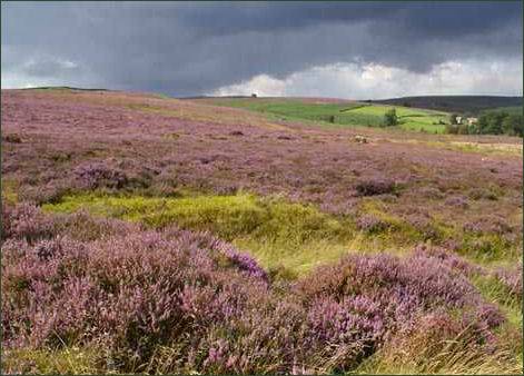 Spectacular Nidderdale, with its stunning moorland scenery and tapestry of lush green meadows is a landscape of contrasts, although outside the Yorkshire Dales National Park it was designated Area of Outstanding Natural Beauty in 1994 and covers an area of 233 square miles (603 km2).
The dale consists of the upper valley of the River Nidd, which flows south underground and then along the dale, forming several reservoirs including Gouthwaite Reservoir, before turning east and eventually joining the River Ouse.
The AONB covers a much wider area than Nidderdale itself and includes part of lower Wharfedale, the Washburn valley and part of lower Wensleydale and the side valleys west of the River Ure.
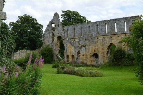
Nidderdale contains the atmospheric ruins of Jervaulx Abbey, one of the great Cistercian abbeys of Yorkshire, which stand at East Witton near Ripon. It is possibly the largest privately owned Abbey. The name Jervaulx is first recorded in 1145, where it appears as Jorvalle. It means means 'Ure valley' in French, and may be a translation of the English Uredale. The abbey originated as a Savigniac foundation and was later taken over by the Cistercian order from Burgundy. It was founded in 1146 by Peter Quintain a Cistercian monk from land granted to him by the Alan, Earl of Richmond in 1145 at Fors near Aysgarth, then moved a decade later to a site by the River Ure. During the reign of King Stephen, in 1145, Akarius Fitz Bardolph, Lord of Ravensworth, gave Peter de Quinciano, a monk from Savigny, land at Fors and Worton, in Wensleydale to build a monastery.
Other historic buildings in the area include Ripley Castle, a fourteenth century country house estate in Ripley, on the edge of the Yorkshire Dales National Park, open to the public all year round and makes for a fascinating and entertaining day out, in a beautiful location. The castle is steeped in history with magnificent grounds, lakes, Deer Park, Walled Gardens, Hothouses and Kitchen Garden. Ripley Castle has been home for twenty-six generations of the Ingilby family. The Old Tower dates from 1555 and houses armour, books, panelling and a secret Priest's Hole, together with fine paintings, china, furnishings and chandeliers. Toft Gate Lime Kiln is a largely intact piece of Nidderdale's industrial heritage which is situated on Greenhow Hill around 2 miles from Pateley Bridge.
 The western side of the Nidd Valley consists of a remote gritstone moorland, marked by rocky outcrops and carpeted with vast swathes of heather. To the east the landscape is softer with rolling farmland, sheltered river valleys and picturesque stone villages. The highest point in the Nidderdale AONB is Great Whernside, which rises to 704 metres, on the border with the Yorkshire Dales National Park.
The only town in the dale is Pateley Bridge, which lies on the River Niid. The town is the start and finish point of Nidderdale Way Long Distance Trail, which runs for 53 miles through the spectacular scenery of the Nidd Valley, the Six Dales Trail, which runs for 38 miles from the Jubilee Tower in Otley to the Market Cross in Middleham also passes through the Pateley Bridge. Nidderdale also includes the villages of Lofthouse, Wath, Ramsgill, Middlesmoor above Pateley Bridge, and Bewerley, Glasshouses, Summerbridge, Dacre, Darley, Birstwith, Hampsthwaite and Kettlesing below Pateley.
Coldstones Cut is a man made land sculpture cut in to the side of Coldstone limestone quarry, the views from there are stunning and on a clear day, it is possible to see all the way to the Yorkshire coast. Brimham Rocks are amazing balancing rock formations on Brimham Moor. The rocks stand at a height of nearly 30 metres, there are many variations of rock formations, caused by the erosion of Millstone Grit by water, glaciation and wind, some of which have formed weird and fantastical shapes. Many of the formations have names, including the Sphinx, the Watchdog, the Camel, the Turtle and the Dancing Bear.
Yorkshire's 'Little Switzerland', or How Stean Gorge as it's more commonly known, carved out over thousands of years by waterflow, The gorge is nearly a kilometre long (1/2 mile), and is as much as 80 feet deep in some areas, it is crossed by several narrow bridges. At the Via Ferrata, visitors can experience the thrills of balancing on beams and ladders and traversing the rock face above the rushing water.
The fantastic geological formations of Stump Cross Caverns, one of Britain's premier show caves, descend to 20 metres below the surface and contain amazing limestone formations. The caves at Stumps Cross were discovered in 1860 by miners who looking for lead seams in the Yorkshire Dales. Thornborough Henges, which have been referred to as 'The Stonehenge of the North', is one of the most important ancient sites in Britain. It consists of an unusual prehistoric monument complex which features three aligned henges from which the site derives its name.
Thornborough Henges have been described by English Heritage as "the most important prehistoric site between Stonehenge and the Orkneys". The Scheduled Ancient Monuments stand along a flat plateau of land between the Rivers Ure and Swale and are located close to the villages of Thornborough and West Tanfield. The complex includes several huge ancient structures which include a cursus, henges, burial grounds and settlements, which are believed to have once formed part of a Neolithic and Bronze Age 'ritual landscape' which date back from between 3500 and 2500 BC.The atmospheric Druid's Temple is located in woodland, high above Pot Beck and stands around 4 miles to the west of the small town of Masham. It is not a real prehistoric temple, but a folly, fashioned after stone circles and prehistoric monuments such as Stonehenge and was built by William Danby of nearby Swinton Hall in 1820.
The Nidderdale Way is 53 mile long circular walk that runs along the length of Nidderdale, passing a variety of landscapes from riverbank to moors. The route takes in Pateley Bridge, the Nidderdale Villages of Glasshouses, Smelthouses, Feliscliffe, Shaw Mills, Ripley, Hampsthwaite, Birstwith, Darley, Summerbridge, Dacre Banks, Bewerley, Ramsgill, Middlesmoor, Scar House Reservoir, Gouthwaite Reservoir, Wath and back to Pateley Bridge.