The East Riding
 The East Riding of Yorkshire, one of three ridings including the North Riding and West Riding constituted a county until 1974. The word Riding is derived from the Old Norse word 'thridding', meaning a third. The invading Vikings called representatives from each Thridding to a thing, or parliament and established the Ridings System.
The landscape of East Yorkshire consists of a crescent of low chalk hills, the Yorkshire Wolds, surrounded by the low-lying fertile plains of Holderness and the Vale of York. The Humber Estuary and North Sea mark its southern and eastern limits.
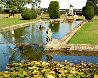
There are a wide variety of interesting places to visit in the East Riding. These include historic buildings such as Burnby Hall Gardens and Museum, situated in the market town of Pocklington, on the edge of the Yorkshire Wolds. The iconic Yorkshire Gardens have been described as "a jewel in Yorkshire's Crown" and have been awarded the prestigious Yorkshire in Bloom Gold Award for five consecutive years. The Upper and Lower Lakes are home to a National Collection of over 100 varieties of Hardy Water Lily, and offer a wonderful array of changing vistas. The Gardens also include a Rockery, Stumpery, a Victorian Garden, Secret Garden, formal beds and natural shrubbery.
Burton Agnes Hall (below right) an Elizabethan manor house in the village of Burton Agnes, near Driffield. The hall was constructed by Sir Henry Griffith in 1601-10 to designs attributed to the celebrated Elizabethan architect Robert Smythson. The medieval Burton Agnes Manor House, which dates to 1173, still stands on an adjacent site and retains an impressive vaulted Norman undercroft. Sewerby Hall, a major tourist attraction in the East of Yorkshire, is situated in a dramatic cliff top position in the village of Sewerby, 2 miles (3.2 km) from the seaside town of Bridlington. The Grade I listed Georgian country house, set in 50 acres of landscaped gardens, was built by John Greame between 1714-1720, replacing a manor house which previously occupied the site.
 Skipsea Castle was built in 1086 by Drogo de la Beuvriere, who was married to the niece of William the Conquerer. The castle was constructed to secure the newly conquered region following William the Conqueror's Harrying of the North and to defend against any potential Danish invasion. It is the finest example of a Norman motte and bailey to survive in England although all that now remains is a grassed mound.
Religious edifices in East Yorkshire include Rudston Monolith, the tallest standing stone in Britain, it measures over 7.6 metres (25 feet) high, nearly 2 metres wide, a metre thick, and has an estimated weight of around 40 tons. The megalith is situated in the churchyard in the village of Rudston.
Magnificent Beverley Minster, the parish church of the market town of Beverley , is one of the largest and most beautiful parish churches in Britain, measuring 393 feet long, it is larger than many cathedrals. The church consists of long nave, twin transepts, choir, sanctuary and a retro quire. Although never given the status of a cathedral, the minster at Beverley, which was once the capital of the East Riding of Yorkshire, was a wealthy college church until the Dissolution of the Monasteries, when it was reduced to a parish church. St. John of Beverley (died 7 May 721), an English bishop active in the kingdom of Northumbria, founded a monastery in about 700 AD in marshy woodland in East Yorkshire. Lots of beavers inhabited the woods at that time, hence, tradition relates, it became known as Beaver Ley.
 Howden Minster, once one of the largest churches in the north of England, has its origins in the eighth century. The Saxon princess St Osana is believed to buried there. The present church was begun after Howden was used by the Prince Bishops of Durham as a centre of administration. Work began on the Minster in 1228, although it was not completed until the fifteenth century when the chapter house and top of the tower was added by Bishop Walter de Skirlaw.In the fourteenth and fifteenth centuries, Howden became a centre for pilgrims due to John of Howden's alleged miracles in the latter part of the thirteenth century.
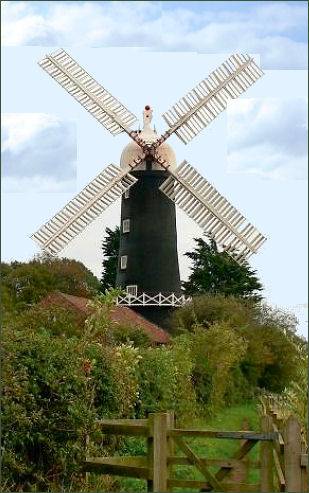
The sails of Skidby Windmil (pictured left) can be seen providing the power to grind flour on certain days, and natural sites provide interest at unique Spurn Point, one of the most striking features of Britain's coastline, is a narrow crooked finger of sand on the the East Yorkshire coast which reaches out into the North Sea and forms the north bank of the mouth of the Humber estuary. The spit is over 3 miles (4.8 km) long, and is now as little as 50 yards (46 metres) wide in places. Spurn has formed as a result of sediment, sand and gravels washing down the Holderness coast and by the interaction between the North Sea and the River Humber. A dynamic site, it is constantly changing, moving westwards as the North Sea and Humber meet.
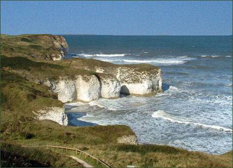
Flamborough Head (above left) with its gleaming white chalk cliffs which drop sheer into the North Sea, is situated between the Filey and Bridlington bays on the east Yorkshire coastline. The cliffs at Flamborough Head are designated a Site of Special Scientific Interest for both geological and biological significance. The headland is one of the most spectacular areas of chalk cliffs in Britain, it is is 8 miles (13 km) long, as well as its distinctive white cliffs, there are coves, sea caves and stacks along the coastline. Flamborough Head has two standing lighthouse towers on its cliffs, the oldest dating from 1669 and Flamborough Head Lighthouse which was built in 1806. The lighthouse was built by John Matson of Bridlington and is 85 feet tall. The lamp mechanism rotates constantly on a bed of mercury.
Bempton Cliffs, which lies on the north side of Flamborough Head, has an RSPB reserve and visitor centre which provides guided walks of the area. From April to August, the cliffs are alive with nest-building adults or young chicks. Visitors may watch the birdlife from safe cliff-edge viewing platforms. Inside the seabird centre is an exhibition area, with large TV screens screening live images from the cliffs.
The name given to the massive bank and ditch earthwork of Danes Dyke is misleading, as it seems to infer that it was constructed by Danish invaders, while it does in fact, date back to the Iron Age. The earthwork divides the Flamborough Head peninsula from the mainland. Danes Dyke is a Scheduled Ancient Monument of national importance.The exact date of the construction of the dyke is not certain, while some date it to the Iron Age, other sources suggest similarities to post-Roman earthworks. Danes Dyke was intended as a defensive structure to protect headland settlements. It consists of two constructed features, a flat-topped bank and a west-facing ditch. The bank was constructed from earth, stacked turfs and chalk rubble, much of which would have come from the ditch. The Dyke runs for 4km (about 2.5 miles) from the Danes Dyke Nature Reserve in the south to Cat Nab on the Bempton Cliffs in the north, enclosing a total area of about 5 square miles, and includes the most northerly outcropping of coastal chalk in Britain.
The coastal village of Flamborough stands on the prominent headland of Flamborough Head, with its rugged white cliffs, the highest cliffs on the East Coast. The village lies around 4 miles (6 km) to the north-east of the popular coastal resort town of Bridlington. Flamborough village is thought to have been originally settled over 1,100 years ago by Vikings, it is mentioned as "Fleneburg" in the Domesday Survey of 1086.
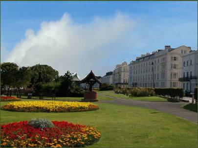 The traditional small seaside town of Filey (right) lies between Scarborough and Bridlington. Once a fishing village, Filey has a large beach and became a popular tourist resort. The oldest building in the town is the parish church on Church Hill, which is dedicated to St Oswald and dates to the twelfth century. In circa 1830, the now Grade II listed Langford Villa was built and later became the summer residence of the Terry's family, the famous York chocolatiers. Shortly later, in 1835, Birmingham solicitor John Wilkes bought seven acres of land and built the crescent, later to become known as the Royal Crescent, which was opened in the 1850s.
The coastal resort town of Bridlington in the the East Riding is situated around 16 miles to the south east of Scarborough and just to the south of Flamborough Head. The town offers two sandy beaches, award-winning promenades and a historic working harbour. The Gypsey Race stream runs through the town and flows into the North Sea at the harbour, which is a hive of activity with fishing boats bringing in the day's catch. There is also a funfair, kids' corner and donkey rides and speedboat rides across the bay and North Sea fishing expeditions on offer. Bridlington Old Town is brimming with character and has remained largely unchanged for centuries, with its olde worlde pubs, antique shops, art galleries and tearooms. The Bayle Museum (pictured above right) in the old town is housed in what was once the gatehouse of medieval Augustinian Bridlington Priory, a sheduled ancient monument.
The deserted medieval village of Wharram Percy occupies a remote but attractive site on the chalk Wolds of Eastern Yorkshire. Wharram Percy is the best known medieval deserted village in England, although there are many others. The village was researched by combined teams of archaeologists, historians and even botanists, from about 1950 to 1990 after its identification in 1948 by economic historian Professor Maurice Beresford of the University of Leeds.