Carl Wark
OS grid reference:- SK 259 814
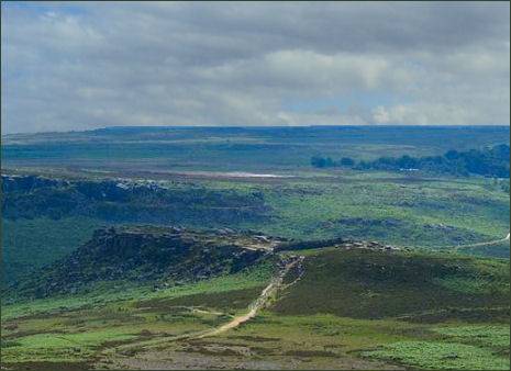 Carl Wark, a rocky promontory on heather moorland near Hathersage, is situated just within the Yorkshire side of the border with Derbyshire, near to Higgar Tor and lies between Stanage and Burbage Edges and just inside the boundary of the city of Sheffield, which lies about 3 miles to the north east.
The hill rises to a height of 370 metres (1,214 feet) and was fortified during the Iron Age or earlier, at around the same time as Mam Tor, which lies around 10 miles to the west and is visible from Higgar Tor.
Carl Wark escarpment hill fort is a recognised as a nationally important archeological site and has been described as 'amongst the most spectacular and easily accessible forts in the country'. The promontory measures around 230 metres (750 feet) long and is 60 metres (200 feet) wide.
To the west the promontory slopes down gently, its peak covers an area of about 1.7 acres and is enclosed by steep cliffs with added fortifications. The eastern and north-eastern sides of the enclosure are edged with high cliffs measuring around 10 metres (33 feet) high.
The southern edge of the enclosure at Carl Wark is edged by rocks which have been reinforced with millstone grit blocks, together forming a wall of around 2.5 metres (8.2 feet) high.
There is also a rampart measuring 40 metres (130 feet) long and 8 metres (26 feet) wide constructed at the western end of the promontory. This rises to a height of 3 metres (9.8 feet) and takes the form of a turf bank which is lined with gritstone blocks. The only entrance to the fort is in the southern wall, which passes through the rock face. Carl Wark is situated in an area which is rich in Bronze Age remains and include cairn, ring cairn and field systems.
 The date of construction of the defensive structures at Carl Wark is not certain, it has been described as being unlike any other found in Northern England. Carl Wark is believed to be a hill fort of Iron Age origin, perhaps dating from the eighth to the fifth centuries BC. More recent assessments believe that the site may have been used since the Neolithic (New Stone Age) era.
There is no evidence of settlement within the enclosure and it has been suggested that it may have been used as a place of refuge for a population living in the surrounding area.
The origin of the name Carl Wark are not known with certainty. It has been suggested that the name is of Old Norse origin and means 'The Old Man's Fort', the carl being a synonym for the Old Man or the Devil. Which may mean that ninth and tenth century Viking settlers in the area regarded the enclosure as ancient.
Excavations carried out in 1950 by F G Simpson which revealed the construction of the rampart but provided no evidence of their date.
Directions
From Sheffield take the A625 road to Bakewell. Turn off at the A6187 to Hathersage. Continue for around a mile then take the next right turn towards Ringinglow. Continue for a mile along this road to find a footpath marker by a gate. Follow the footpath to access the fort.
Prehistoric and Roman Sites of Yorkshire
Historic Buildings of Yorkshire