Stanage Edge
OS Grid reference- SK 228 853
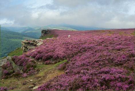 Stanage Edge, a dramatic gritstone escarpment rises to 458 metres (1,503 feet), the northern part of the edge forms the border between the High Peak of Derbyshire and South Yorkshire.
The stunning view from the gritstone escarpment is one of the most spectacular in the Peak District, extending across the Hope Valley, the Upper Derwent Valley, and towards Chatsworth House which lies to the south, the view to the north takes in dramatic Kinder Scout and Win Hill.
Stanage Edge is the largest of the gritstone edges in the Peak District National Park and was formed during the last Ice Age, some 10,000 years ago. Once a private grouse moor, it is now a highly popuar location with climbers and walkers, and has good footpaths beneath it and a path along its edge.
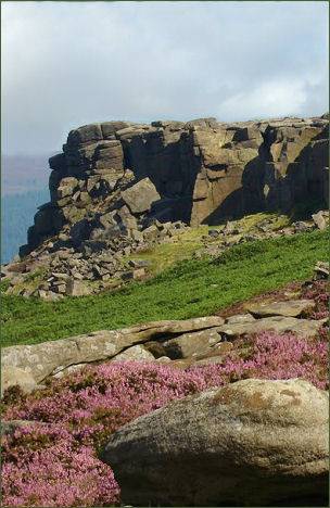 There are over 500 climbing routes on Stanage Edge, where one sheer gritstone face is named "The Unconquerable".
The highest point on Stanage Edge is High Neb which rises to 458 metres (1,503 feet). The edge runs for four miles from the Cowper Stone at the south to Stanage End, many of the Edges acquire their names from the villages which lie in their shadow, such as Baslow Edge, Froggatt Edge and Curbar Edge. The rock face itself reaches a maximum height of 25 metres, but for most of its length it is between 15 and 20 metres in height. A short walk leads from nearby Redmires along signposted moorland footpaths to Stanage Edge.
There are over 500 climbing routes on Stanage Edge, where one sheer gritstone face is named "The Unconquerable".
The highest point on Stanage Edge is High Neb which rises to 458 metres (1,503 feet). The edge runs for four miles from the Cowper Stone at the south to Stanage End, many of the Edges acquire their names from the villages which lie in their shadow, such as Baslow Edge, Froggatt Edge and Curbar Edge. The rock face itself reaches a maximum height of 25 metres, but for most of its length it is between 15 and 20 metres in height. A short walk leads from nearby Redmires along signposted moorland footpaths to Stanage Edge.
The Cowper Stone is a block of gritstone at the most southerly point of the Edge, standing solitary a few hundred metres from the last buttress of the main crag, it is a large boulder with distinctive rounded breaks running across it. The small cave and ledge at the upper section of the escarpment is known as Robin Hood's Cave, where legend states the outlaw was said to have used as a hideaway.
The remains of a paved packhorse road which once ran along the top of the edge is still visible, as are the remains of the Long Causeway Roman road which crosses the edge on its route from Templeborough to Brough-on-Noe, crossing Hallam Moor and passing the ancient waymarker known as Stanedge Pole. The tall wooden pole has been replaced many times over the centuries, but its supporting rock base is carved with the date 1550. During the industrial revolution the rocks were used to produce grindstones and remnants are still visible.
In recent years film producers have chosen the edge for the setting of the 2005 film adaptation of Pride and Prejudice starring Keira Knightley, as well as the 2006 BBC production of Jane Eyre.
The name Stanage Edge derives from "stone edge". Car Parks are provided at Hollins Bank & Picnic area (OS grid ref- SK237837) Hook's Car (SK246829) and Dennis Knoll (SK228843).