Keld
OS grid reference:- NY 894 009
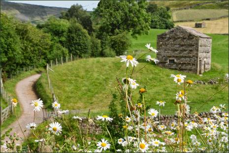 Keld is a characterful, if remote, village at the head of Swaledale, one of most beautiful dales in the Yorkshire Dales National Park. The village lies near to the border with County Durham and about 3 miles to the north of the village of Muker.
Nestling in a hollow below Kisdon, at around 1100 feet above sea level, Keld stands on the banks of the River Swale and boasts stunning views of the valley and hills. The village is surrounded by some of the most superb scenery in the Yorkshire Dales.
 Keld boasts a long history, it was founded by Viking settlers. The village's name derives from the Old Norse word Kelda which means a spring. Keld was once referred to as Appletre Kelde
- meaning the spring near the apple trees.
Keld boasts a long history, it was founded by Viking settlers. The village's name derives from the Old Norse word Kelda which means a spring. Keld was once referred to as Appletre Kelde
- meaning the spring near the apple trees.
Keld has no shop except at Ruskin's campsite. The village contains a number of interesting Grade II listed buildings, these include the Congregational and Methodist chapels, the school and the Literary Institute.
The Keld Resource Centre, a local religious charity, is restoring a series of listed buildings in the village centre and returning them to community use. The first phase involved restoring the Manse, the Minister's house attached to the United Reformed Church, which was completed in 2009 and is now used as a holiday cottage, proceeds from which support the Centre's work.
In 2010 the Centre created the Keld Well-being Garden in the chapel churchyard. It provides a quiet spot for visitors to contemplate their well-being in the beautiful natural environment of Upper Swaledale.
The Centre's latest project is the Keld Countryside and Heritage Centre. The centre was opened on 14 May 2011 and provides interpretation of the countryside, buildings and social history of Keld and a small display of artefacts relevant to Upper Swaledale prepared by the Swaledale Museum in Reeth. There is also a verbal community history featuring some of the current residents including the eldest resident of Keld. The centre is open throughout the year. Further projects involve restoring the former school, the Literary Institute and, potentially, the Methodist Chapel.
Keld Lodge is a former shooting lodge and youth hostel is now a comfortable hotel and restaurant which offers high quality accommodation and excellent food and real ales.
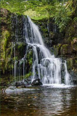
Keld is the crossing point of the Coast to Coast Walk and the Pennine Way long-distance footpaths. The Coast to Coast walk was initiated by Alfred Wainwright who frequented Keld often as knew the owner of Butt House which is situated on the outskirts of the hamlet. There is a series of four waterfalls close to the village in a limestone gorge on the River Swale, Kidson Force, East Gill Force, Catrake Force and Wain Wath Force.
Crackpot Hall
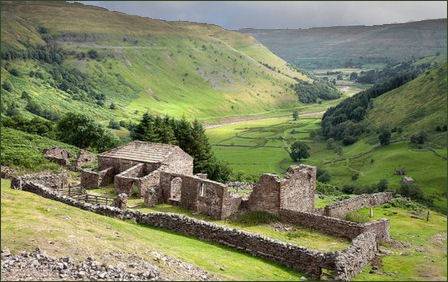 The ruins of Crackpot Hall (pictured right) are situated about a mile to the east of Keld on the northern slope of the dale (OS grid reference NY906008). A building may have occupied the site since the sixteenth century when a hunting lodge was maintained for Thomas, the first Baron Wharton, who visited the Dale occasionally to shoot the red deer. Survey work by the Yorkshire Dales National Park Authority has shown that the building has changed many times over the years. At one time it even had a heather or "ling" thatched roof. The name Crackpot is said to be Old Norse for "a deep hole or chasm that is a haunt of crows".
The current ruin is of a farmhouse dating from the mid eighteenth century. It was an impressive two-storey building with a slate roof and matching "shippons" or cow sheds at each end for animals. The building may also have been used as mine offices, as intensive lead mining was carried out in the area.
The current building was abandoned in the 1950s because of subsidence. Crackpot Hall has been saved from further decay by Gunnerside Estate with the aid of grants from the Millennium Commission and European Union through the Yorkshire Dales Millennium Trust.
Towns and Villages of Yorkshire