Spurn Point
OS grid reference:- TA 399 108
 Unique Spurn Point, one of the most striking features of Britain's coastline, is a narrow crooked finger of sand on the the East Yorkshire coast which reaches out into the North Sea and forms the north bank of the mouth of the Humber estuary. The spit is over 3 miles (4.8 km) long, and is now as little as 50 yards (46 metres) wide in places.
Spurn has formed as a result of sediment, sand and gravels washing down the Holderness coast and by the interaction between the North Sea and the River Humber. A dynamic site, it is constantly changing, moving westwards as the North Sea and Humber meet.
In Medieval times, Spurn Head housed the port of Ravenspur, where Henry of Bolingbroke landed in 1399 to usurp the throne of his cousin Richard II and become the first king of the House of Lancaster. It was also where Sir Martin De La See led resistance against the Yorkist king, Edward IV's landing on 14 March 1471, when he was returning to England after spending six months in exile in the Netherlands.
Spurn Point is now a nature reserve, owned by the Yorkshire Wildlife Trust.and consists of beach, mudflats, saltmarsh, dunes, grassland, saline lagoons and native sea buckthorn scrub.
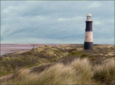
Spurn Point Lighthouse lighthouse is a round brick tower, measuring 128 feet (39 metres) high, it was built in 1895. Following a tidal surge in December 2013 the roadway is currently unsafe, and access to Spurn Point is on foot only.
Wildlife at Spurn Point
 Spurn is a wildlife haven, with marram grass dunes mingled with stunted elder and bright orange-berried sea buckthorn bushes and sea holly.
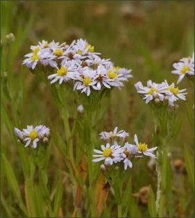
 On the Humber side of Spurn, a strip of saltmarsh lies between the land and the mudflats, supporting colorful flowering plants including sea lavender, sea aster (right) and sea rocket, along with common glasswort and eel grass.
In the summer months a wide range of wildflowers appear in the grassland areas which the Trust manages by grazing Hebridean sheep.
Spurn Point is an important location for studying bird migration and has long been a focus of interest for ornithologists and naturalists. The bird observatory monitors migrating birds and provides accommodation to visiting birdwatchers.
Curlew, grey plover and knot use the saltmarsh to roost, Dunlin, Redshank and Curlews feed on the mudflats, while shelduck and brent geese are sighted on the mudflats during the winter months. In August and September bird watchers can spot Wheatear, Whinchat, Redstart, and Spotted Flycatchers.
Roe deer are regularly sighted in the grassy areas, particularly early in the morning. Spurn Point is also an important wildlife haven for reptiles including the common lizard. Humpback whales are occasionally sighted.