Stamford Bridge
OS grid reference:- SE 710 550
 The large and pleasant village of Stamford Bridge is famous for the battle that took place there in 1066 between King Harold Godwinson and Harald Hardrada, King of Norway, the fore runner of the fateful Battle of Hastings, which radically changed England's history forever. The village lies on the River Derwent in the East Riding of Yorkshire and is situated around 7 miles (11 km) to the east of the city of York.
Stamford Bridge stands at the site an ancient ford on the River Derwent. The Romans constructed a fort there in about 70 AD, around which a settlement known as Derventio developed, the remains of which were recently discovered. Stamford Bridge was known as Pons Belli to the Normans, which translates as battle bridge.
 A river crossing has existed at Stamford Bridge since at least Roman times. There was a bridge at or near the village in the eleventh century as one is mentioned in accounts of the battle of 1066, as recorded in the Anglo-Saxon Chronicle.
Archaeological research has revealed that there was once a bridge crossing of the River Derwent one mile (1.6 km) to the south of the present village which linked the east and west bank of the Roman settlement of Derventio.
In the medieval period a new bridge was constructed, which was made of timber and supported on three stone piers. In the eighteenth century the weir and the by-pass canal and lock were built and the medieval bridge was replaced with the current structure. The present bridge was designed by William Etty of York and was completed in 1727.
One of the oldest buildings in the village is the corn mill which dates back to 1591. However the original mill was most likely in existence on that same spot in 1130. The building was still in operation as a mll in 1847 when it was expanded to include seven grinding stones and two water wheels. The mill finally closed in 1964 and has since been converted into luxury apartments.
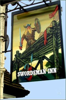
The village has a range of amenities including a post office, a convenience store, newsagent, butcher, baker and a pharmacy. There are three pubs: The Swordsman, The Bay Horse, which dates to the late eighteenth to early nineteenth century and the Three Cups which has an ancient draw well which is 23 feet deep, first discovered by the landlord during building works in the 1960's. This well is still visible today through a porthole in the floor of the pub.
There is a Methodist Church in the Village Square and a Church of England church of St John the Baptist, located on Church Road which dates to 1868.
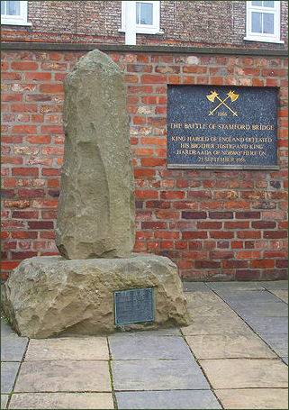
Two monuments to the battle have been erected in and around the village, The first of these is located on Main Street, a second monument is located at the battlefield site itself at the end of Whiterose Drive. This monument consists of a memorial stone and plaque detailing the events and outcome of the battle.
There are well signposted public footpaths along the River Derwent both towards Low Catton and Buttercrambe, which offer atttractive rural scenery. The route of The White Rose Way, a long distance trail from Leeds to Scarborough, also passes through the village.
Battle of Stamford Bridge
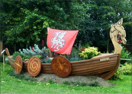
 The Battle of Stamford Bridge on 25 September 1066, when King Harold Godwinson of England defeated the armies of King Harald Hardrada of Norway marked the end of the Viking era in Britain.
Hardrada arrived off the English coast in September, where his army was reinforced by Tostig Godwineson, the unruly and discontented brother of Harold, at the head of forces from Flanders and Scotland. Continuing to travel both day and night, Harold marched his army relentlessly from London to Yorkshire, a distance of about 185 miles, in only four days, which enabled him to take the Norwegians completely by surprise.
The Viking army, caught unaware by the English, was divided, with some of their troops positioned on the west side of the River Derwent and the bulk of their army on the east side. By the time the main English army had arrived at the scene, the Vikings on the west side of the river had either been killed or were fleeing across the bridge.
The English attempted to follow across the bridge but were delayed by the need for the army to pass through the bottle neck presented by the bridge itself. A huge Viking berserker clutching a massive double-bladed greataxe blocked this narrow crossing, single-handedly holding up the entire Saxon army. The Anglo-Saxon Chronicle records that he slew up to 40 Englishmen. He was finally defeated when an Anglo-Saxon soldier floated under the bridge in a half-barrel and thrust his long spear through the laths in the bridge, mortally wounding him.
The delay created by the beserker had allowed time for the bulk of the Viking army to form a shield wall, in the shape of a triangle against the English attack. The Anglo-Saxon army poured across the bridge and formed a line just short of the Vikings, they then locked shields and charged. The battle was fierce and bloody and raged for hours. Eventually, the Viking army began to fragment and fracture, allowing the English to break in through the shield wall. The firce fighting continued throughout the afternoon. The massive Viking King Hardrada, who, according to the sagas, wore a blue tunic and helmet and wielded a two-handed sword, advanced ahead of his army and in true beserker style, dealt devastating blows to all around him. As dusk drew near, he was killed by an arrow to his windpipe. Tostig took up the fallen Viking Raven Banner, "Land-Ravager" and continued to rallly the troops and fight on but was himself slain.
 Harold's victory was however, short-lived, while celebrating his victory at a banquet in York, he received news that William of Normandy had landed in Sussex on the south coast of England and hurried south to meet him, where he was defeated and killed at the Battle of Hastings on 14th October.
The site of the initial action, for control of the bridge, is believed to have to been located. However, the exact location of the main battlefield is more difficult to determine, due to the the lack of landscape description in the original sources. The area known as 'Battle Flats' to the south-east of the vilage is thought to be the correct location.
The site of the bridge lies within the built up area, although the northern bank of the river is only partly developed. The village of Stamford Bridge has grown considerably in the late twentieth century, with new houses being built on the Registered Battlefield. However the greater part of Battle Flats remains as agricultural land, so a significant part of the battlefield may survive
Access is via this road, following the Minster Way long distance path. There is also another footpath which gives access to the east side of the battlefield. Access to the core of the battlefield is not possible. The area of the river crossing has been very much altered over the years but access is possible at several points along the river.
Images 1 and 5 Courtesy of Æthelred
Towns and Villages of Yorkshire