Stainforth
OS grid reference:-
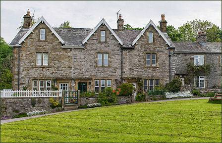 The pretty village of Stainforth, in the west of the Yorkshire Dales National Park, lies to the east of the River Ribble. The village is located in Ribblesdale, one of the twenty Dales that make up the beautiful Yorkshire Dales. Stainforth stands in the shadow of Stainforth Scar, and is 2½ miles to the north of the bustling market town of Settle and 3 miles to the south of Horton-in-Ribblesdale.
 The village's name derives from the 'stony ford' which linked two settlements half a mile apart, standing on opposite banks of the River Ribble.
The settlement is recorded in the Domesday Book of 1086 as Stainforde. Stainforth, on the eastern side of the river, was formerly owned by Sawley Abbey near Clitheroe in Lancashire, whose monks developed the estate which prospered, while Little Stainforth, also known as Knight Stainforth, under private ownership, declined.
The village church of St Peter, a Grade II listed building, is a fine example of an early Victorian church and contains interesting memorials and stained glass. The church was built at the instigation of three sisters from a local gentry family, the Dawsons. It was constructed between 1839 and 1842 to a design by the Lancaster architect Edmund Sharpe.The stained glass in the east window and some of the other windows is by William Wailes. Above the east window is the heraldic shield of the Dawson family.
Stainforth Beck runs through the centre of Stainforth, its focal point being stepping-stones which cross it and connect village greens at either side of the beck. The village pub, the Craven Heifer, wich stands beside the beck, offers a warm welcome, the inn offers good food and quality bed and breakfast accommodatiion.
Knight Stainforth was held in the thirteenth and fourteenth centuries by the de Stainford family until it became extinct in the male line, when it passed, by marriage, to the Tempest family. One member, Sir Richard was knighted (hence Knight Stainforth) after the battle of Wakefield in 1460. He died in 1488 and his descendants held Knight Stainforth until 1511 when again it passed by marriage to the Darcy family.Knight Stainforth Hall, a manor house was built in its present form in 1649 by Samuel Watson, a prominent Quaker, although a manor house has occupied its site, on the banks of the River Ribble, since medieval times.
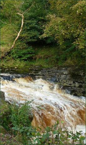
Stainforth Force lies just to the west of the village. The River Ribble tumbles over a series of limestone ledges into a deep, broad pool. Salmon can often be sighted leaping on their final journey up river to their spawning grounds. Above the waterfall an old Pack Horse Bridge crosses the River Ribble. the bridge dates back to 1675. It was built by Samuel Watson to replace a ford which was previously used to cross the river and is now owned by the National Trust.
The footpath from Stainforth to the waterfall is part of the Pennine Bridleway National Trail which runs through the village and there are several other interesting footpaths leading to and from the village. To the north of the village leads ¾ mile to the splendid Catrigg Force Waterfall, which is situated in a wooded gorge.
Towns and Villages of Yorkshire