Thwaite
OS grid reference:- SD 89 98
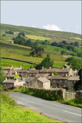
 The pretty and unspoiled village of Thwaite is situated in beautiful Upper Swaledale, a remote dale and one of the northernmost valleys in the Yorkshire Dales National Park.
 The name 'Thwaite' derives from the Old Norse language, from the word þveit, meaning 'clearing, meadow or paddock'.
Parts of the Swaledale are particularly striking due to the large old limestone field barns which litter the landscape and its stunning profusion of wild flowers. From Thwaite and near the head of the dale the famous Buttertubs Pass leads up over the high moors and down into neighbouring Wensleydale. The road winds its way north from Simonstone near Hawes towards Thwaite and Muker past 20 metre deep limestone potholes called the Buttertubs. It is said that the name of the potholes came from the times when farmers would rest there on their way to market. During hot weather they would lower the butter they had produced into the potholes to keep it cool.
Thwaite is situated low on the north bank of Thwaite Beck, which is crossed by a quaint stone bridge. The village is over looked by Kisden Hill which rises to 499 metres (1,637 feet) and was named by early Norse settlers.
The village was the home and birthplace of the brothers Richard and Cherry Kearton, the sons of a local gamekeeper, who became writers and pioneers in wildlife photography at the end of the nineteenth century. The brothers left the Yorkshire Dales to pursue their careers. Richard Kearton (1862-1928), a naturalist, reached the Outer Hebridean islands of St Kilda and many other remote places, such as the African savannah and the Australian outback. Cherry (1871–1940) become a famous wildlife documentary filmmaker and was the source of inspiration for a young David Attenborough.
 The Kearton surname lives on in the Kearton
Café, Restaurant (pictured below right) and guesthouse which stand in the centre of the village. The Kearton Café and Restaurant has recently been refurbished. The restaurant has a large dining room, offering reasonably priced food.
The Kearton surname lives on in the Kearton
Café, Restaurant (pictured below right) and guesthouse which stand in the centre of the village. The Kearton Café and Restaurant has recently been refurbished. The restaurant has a large dining room, offering reasonably priced food.
Kearton Country Hotel in Thwaite provides a warm traditional Yorkshire welcome. The cosy hotel bar has an open fire and serves a selection of local ales, as well as a wide selection of fine malts. The hotel also serves delicious food and clean, and comfortable ensuite accommodation.
Thwaite Congregational Chapel is a Grade II listed building dating back to 1863, since the 1980s it has been in use as two houses.
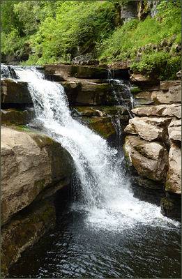
Kidson Force (pictured left) is a picturesque series of waterfalls on the River Swale near Thwaite, (OS grid reference NY 898 010).
It is one of several waterfalls on the Swale in the area, the others are East Gill Force, Catrake Force and Wain Wath Force. All occur where the river cuts a limestone gorge between the hills of Kisdon and Rogan's Seat. Kison Force drops 10 metres (33 feet) over two cascades and are surrounded by Kisdon Force Woods, a Site of Special Scientific Interest. In the springtime wild primroses grow profusely in the area.
There are a number of stunning walks from the village to the nearby village of Muker with its colourful wildflower meadows.
Towns and Villages of Yorkshire